Welcome to a Pearl and Hermes Atoll Street View, by Google. Simply use your mouse for a virtual tour of Pearl and Hermes Atoll (below). Pearl and Hermes is otherwise off-limits to the general public.
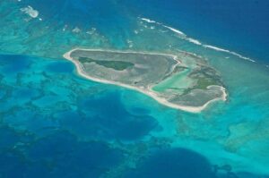
The Atoll is known for its vibrant coral reefs and unique marine ecosystems. Pearl and Hermes Atoll was discovered in 1822 by two whaling ships were named Pearl and the Hermes. It’s important to note that it’s very likely that the island was known to Polynesian navigators.
This atoll has a fascinating history, reflecting both the trials of early mariners and the evolving understanding of oceanic ecosystems. The total land area of the atoll’s islets is relatively small, typically around 80 acres. These islets are mostly sand and coral rubble. The total area of the atoll, including its extensive lagoon and encompassing reef system, is much larger, covering approximately 194,000 acres or 304 square miles. This makes it one of the larger atolls in the Northwestern Hawaiian Islands in terms of total area.